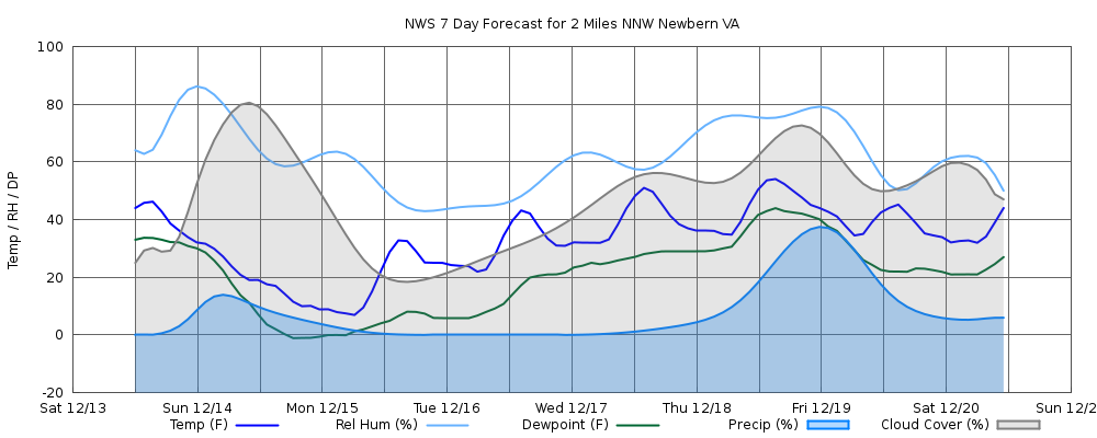
Wed Jun 17
(NWS: This Afternoon)
Day: This Afternoon
Mostly Sunny
H 82° • POP 0%
Night: Tonight
Mostly Cloudy
L 64° • POP 1%
Thu Jun 18
(NWS: Thursday)
Day: Thursday
Partly Sunny then Chance Showers And Thunderstorms
H 86° • POP 47%
Night: Thursday Night
Chance Showers And Thunderstorms
L 63° • POP 50%
Fri Jun 19
(NWS: Juneteenth)
Day: Juneteenth
Slight Chance Showers And Thunderstorms
H 79° • POP 19%
Night: Friday Night
Partly Cloudy
L 56° • POP 2%
Sat Jun 20
(NWS: Saturday)
Day: Saturday
Sunny
H 80° • POP 1%
Night: Saturday Night
Mostly Clear
L 57° • POP 1%
Sun Jun 21
(NWS: Sunday)
Day: Sunday
Mostly Sunny then Slight Chance Showers And Thunderstorms
H 85° • POP 19%
Night: Sunday Night
Slight Chance Showers And Thunderstorms then Chance Showers And Thunderstorms
L 63° • POP 29%
Mon Jun 22
(NWS: Monday)
Day: Monday
Showers And Thunderstorms
H 81° • POP 76%
Night: Monday Night
Showers And Thunderstorms
L 61° • POP 76%
Tue Jun 23
(NWS: Tuesday)
Day: Tuesday
Chance Rain Showers then Slight Chance Showers And Thunderstorms
H 80° • POP 27%
Night: Tuesday Night
Slight Chance Showers And Thunderstorms then Partly Cloudy
L 57° • POP 22%